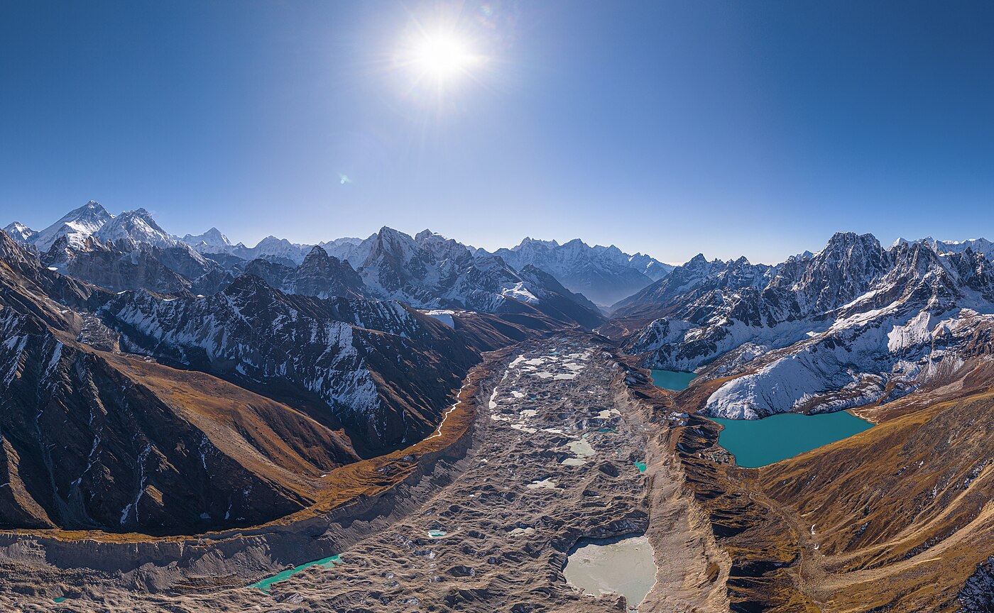
Many trekkers who have done both rate the view from Gokyo Ri above Kala Patthar. From the summit you see Everest, Lhotse, Makalu and Cho Oyu at once, with a chain of turquoise lakes and the Ngozumpa Glacier directly below.
The Gokyo valley runs parallel to the main Base Camp trail and is markedly quieter, which makes this an excellent choice for a second Khumbu trek or a first one away from the crowds.
Trip Highlights
- Gokyo Ri (5,357m) with four 8,000m peaks in a single panorama
- The turquoise Gokyo Lakes, among the highest freshwater lakes in the world
- Ngozumpa Glacier, the longest glacier in Nepal
- Noticeably quieter than the Everest Base Camp trail
- Optional walk to the fourth and fifth lakes and Scoundrel's Viewpoint
- Full acclimatisation schedule with two rest days
Overview
Many trekkers who have done both rate the view from Gokyo Ri above Kala Patthar. From the summit you see Everest, Lhotse, Makalu and Cho Oyu at once, with a chain of turquoise lakes and the Ngozumpa Glacier directly below.
The Gokyo valley runs parallel to the main Base Camp trail and is markedly quieter, which makes this an excellent choice for a second Khumbu trek or a first one away from the crowds.
Trip Highlights
- Gokyo Ri (5,357m) with four 8,000m peaks in a single panorama
- The turquoise Gokyo Lakes, among the highest freshwater lakes in the world
- Ngozumpa Glacier, the longest glacier in Nepal
- Noticeably quieter than the Everest Base Camp trail
- Optional walk to the fourth and fifth lakes and Scoundrel's Viewpoint
- Full acclimatisation schedule with two rest days
Trip Highlights
- Gokyo Ri (5,357m) with four 8,000m peaks in a single panorama
- The turquoise Gokyo Lakes, among the highest freshwater lakes in the world
- Ngozumpa Glacier, the longest glacier in Nepal
- Noticeably quieter than the Everest Base Camp trail
- Optional walk to the fourth and fifth lakes and Scoundrel's Viewpoint
- Full acclimatisation schedule with two rest days
Itinerary of Gokyo Lakes and Gokyo Ri Trek – 12 Days
You are met at Tribhuvan International Airport and transferred to your hotel in Kathmandu. The rest of the day is free to recover from the flight or explore Thamel.
In the afternoon your guide runs the pre-trek briefing, covering the route up the Dudh Koshi and into the Gokyo valley, the acclimatisation plan, and the gear you will need. Sagarmatha National Park and Khumbu municipality permits are arranged at this point, so bring your passport and insurance documents.
Travel insurance covering trekking to 6,000 m with helicopter evacuation is a requirement for this trek, and we will ask to see the policy.
Any missing kit is easily bought or hired in Thamel. Warm layers matter more on the Gokyo route than most people expect: it sits higher on average than the Base Camp trail and the valley is colder.
Overnight in a three-star hotel in Kathmandu.
An early transfer to the domestic terminal for the thirty-five minute flight to Lukla, landing on the short uphill runway at 2,860 m. In the busiest months flights operate from Ramechhap instead, which means an early morning road transfer of four to five hours.
At Lukla you meet your porters while loads are organised, then set off north through the town gate onto the main Khumbu trail.
The first day is easy and mostly downhill, following the Dudh Koshi through Chheplung and Ghat past mani walls and stream-driven prayer wheels. The river runs milky grey with glacial flour, which is what gives it its name.
Around three hours over 8 km, descending some 250 m. The short day is intentional and helps you settle in without pushing altitude on your first afternoon.
Lunch and dinner at the lodge. Overnight in Phakding.
The trail follows the Dudh Koshi upstream, crossing the river repeatedly on high suspension bridges. You register at the Sagarmatha National Park entrance at Monjo, then descend to Jorsalle for lunch.
Past Jorsalle you cross the Hillary Bridge, hung high above the meeting of the Dudh Koshi and Bhote Koshi, and start the long climb to Namche - roughly 600 m of switchbacks through pine forest over two to three hours.
Partway up, if the cloud allows, there is a first sight of Everest behind the Nuptse-Lhotse ridge. Namche Bazaar then appears in its horseshoe bowl at 3,440 m, facing Kongde Ri.
Namche is the commercial centre of the Khumbu, with bakeries, gear shops, ATMs and a Saturday market drawing traders from across the region and over the Tibetan border.
Six to seven hours over 11 km with around 830 m of ascent. All meals provided. Overnight in Namche.
An acclimatisation day spent walking rather than resting - gaining a few hundred metres and returning to sleep low is what actually helps.
The morning walk climbs behind the town past Syangboche to the Everest View Hotel at 3,880 m, where Everest, Lhotse, Nuptse and Ama Dablam line up across the terrace. It is a spectacular place for a pot of tea.
The route then descends through Khumjung, the largest Sherpa village in the area, and Khunde, home to the hospital Edmund Hillary founded, before looping back to Namche.
The afternoon is free. The Sherpa Culture Museum and the national park visitor centre are both worthwhile, and this is the last place with reliable ATMs and hot showers before Gokyo.
Four to five hours of walking with 440 m gained and lost. All meals provided. Overnight in Namche.
Today the route leaves the Base Camp trail. From Namche the path climbs to the high contour and, at Kyangjuma, branches left towards Mong La rather than continuing to Tengboche.
Mong La is a small settlement on a ridge at around 3,970 m with chortens, prayer flags and a superb view of Ama Dablam, Thamserku and Kusum Kangguru. From there the trail drops steeply to Phortse Tenga on the Dudh Koshi.
The afternoon is a sustained climb through rhododendron, birch and juniper forest into the Gokyo valley proper. The forest thins as you gain height, and you are likely to see Himalayan tahr on the slopes and, with luck, musk deer in the trees.
Dole at 4,040 m is a small cluster of lodges on the hillside. The valley here is quieter than the Base Camp route by a considerable margin.
Five to six hours over 12 km with around 600 m of net ascent and a good deal of up and down. All meals provided. Overnight in Dole.
A short day, kept deliberately so because the altitude gain is significant and the valley climbs quickly from here.
The trail rises steadily along the valley side above the Dudh Koshi through Lhabarma and Luza, passing summer grazing settlements and stone-walled yak pastures. The last of the shrubs give out and the landscape becomes entirely alpine.
Cho Oyu, at 8,188 m the sixth highest mountain in the world, comes into view ahead, with Kangtega and Thamserku behind you across the valley. The views open steadily through the morning.
Machhermo at 4,470 m sits in a side valley with a Himalayan Rescue Association post that runs a free altitude awareness talk each afternoon in season - genuinely useful given what lies ahead. The village is also known for a documented yeti sighting in 1974, which the lodges will happily tell you about.
Three to four hours over 7 km with around 430 m of ascent. All meals provided. Overnight in Machhermo.
The trail climbs to a ridge above Machhermo giving a long view back down the valley and ahead to Cho Oyu, then descends to Phangga before following the river up towards the Ngozumpa glacier.
A steep climb beside the glacier's terminal moraine brings you to the first of the Gokyo lakes, Longpongo, where you may see Brahminy ducks on the water. The second, Taboche Tsho, is larger and a startling turquoise against the grey moraine.
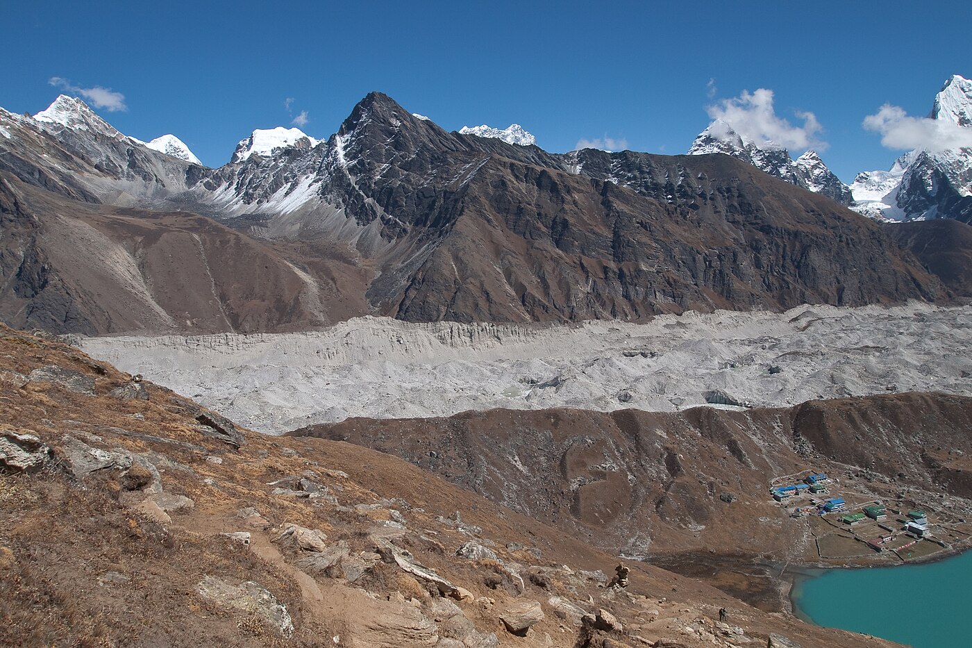
The Ngozumpa is the longest glacier in Nepal, and the trail runs along its lateral moraine with the ice - a vast, rubble-covered river of it - immediately below on the right.
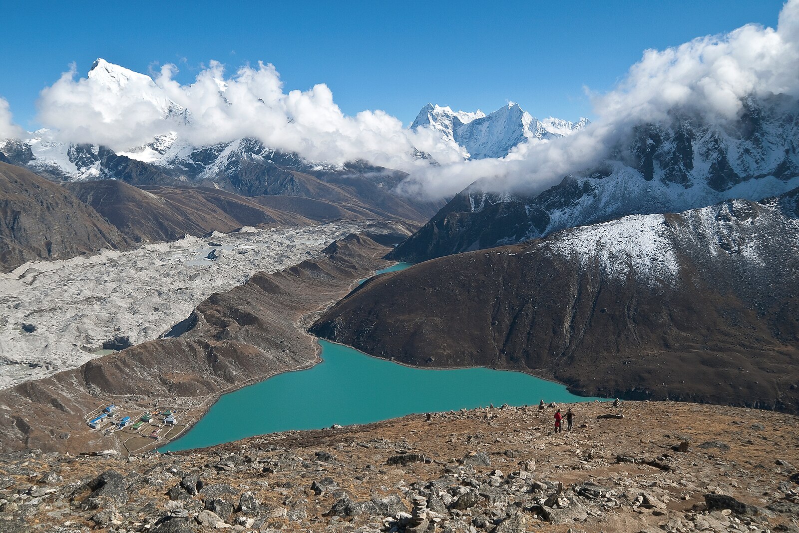
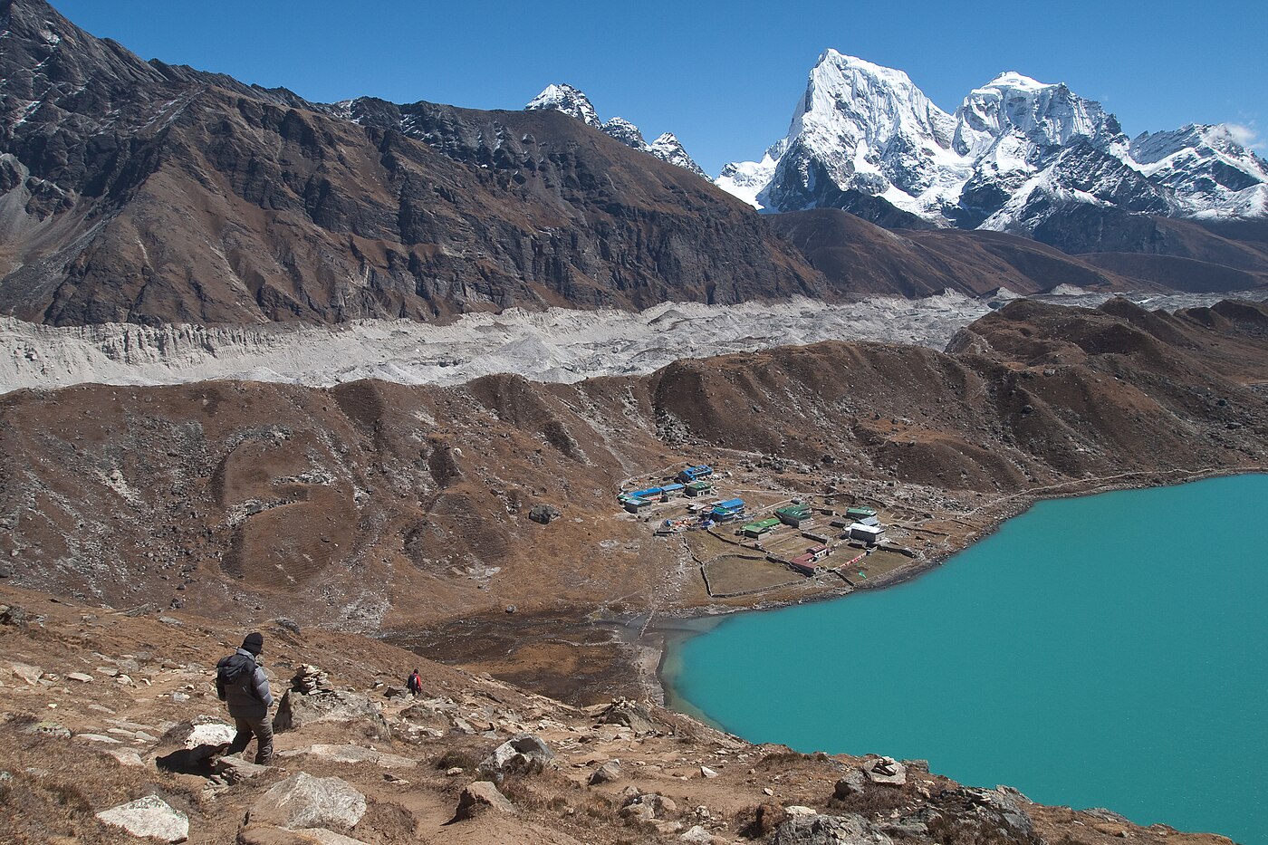
Gokyo village sits at 4,790 m on the shore of Dudh Pokhari, the third and largest lake, a brilliant blue-green sheet of water beneath Gokyo Ri. The lakes are sacred to both Hindus and Buddhists, and a shrine stands on the shore.
Four to five hours over 7 km with around 320 m of ascent. All meals provided. Overnight in Gokyo.
The high point of the trek. An early start for the climb up Gokyo Ri, which rises directly behind the village - a steep, relentless zigzag of some 570 m taking two to three hours at this altitude, with no technical difficulty but plenty of hard breathing.
The summit at 5,357 m carries a mass of prayer flags and gives what many experienced trekkers consider the finest panorama in Nepal: four eight-thousanders visible at once - Everest, Lhotse, Makalu and Cho Oyu - with the Ngozumpa glacier snaking below, the chain of turquoise lakes strung along the valley, and Cholatse and Taboche opposite.
It is a broader and arguably more beautiful view than Kala Patthar, and with a fraction of the people.
After descending for a late breakfast, the afternoon is free. Those with energy can walk north along the lake shore to the fourth and fifth lakes, and to Scoundrel's Viewpoint above the fifth, which looks straight up at the Everest massif.
Three to six hours depending on how much you do, with 570 m gained and lost. All meals provided. Overnight in Gokyo.
The return down the valley begins today, retracing the route along the moraine past the lower lakes and descending beside the Ngozumpa glacier.
Walking south the views are quite different, with the light behind you and the Kangtega and Thamserku wall filling the horizon ahead rather than sitting at your back.
The trail drops through Phangga and climbs the short ridge before Machhermo, then continues down through Luza and Lhabarma. Losing height quickly, the air noticeably thickens and appetite tends to return with it.
Dole at 4,040 m is 750 m below Gokyo, and most people sleep considerably better tonight than they have in several days.
Five to six hours over 12 km, descending around 750 m. All meals provided. Overnight in Dole.
A day of forest walking and a return to greenery. The trail drops steeply from Dole through rhododendron and birch to Phortse Tenga on the river, then climbs back up to the ridge at Mong La.
The climb to Mong La is short but steep, around 300 m, and comes as a surprise on what is otherwise a descending day. From the chortens at the top there is a last full view of Ama Dablam.
From Mong La the trail rejoins the main Khumbu contour path at Kyangjuma and traverses back into Namche with Kongde Ri opposite, passing Sanasa where Tibetan traders sell jewellery and prayer flags from the trailside.
Arriving in Namche in the afternoon there are hot showers, bakeries and a much wider menu than anything above.
Five to six hours over 12 km, descending around 600 m with 300 m of climbing. All meals provided. Overnight in Namche.
The final walking day. The trail drops sharply out of Namche to the Hillary Bridge, then follows the Dudh Koshi downstream through Jorsalle and Monjo, where you sign out of the national park.
The valley greens and warms as you descend, with pine forest and cultivated terraces returning after days above the treeline.
From Phakding the route undulates through Ghat and Chheplung, with several short climbs that feel harder than they are at the end of a long trek, before the last pull up into Lukla.
The evening is traditionally spent with the guides and porters over a final dinner, and this is the customary point for tips.
Six to seven hours over 19 km, descending around 850 m with 300 m of ascent. All meals provided. Overnight in Lukla.
An early transfer to Lukla airport for the thirty-five minute flight back to Kathmandu, or to Ramechhap with an onward road transfer depending on the season. Flights go early, before the valley wind builds.
Lukla flights depend entirely on weather and delays are routine, which is why we strongly recommend a buffer day in Kathmandu before any international flight. If conditions close the airstrip for an extended period, a helicopter can usually be arranged at additional cost.
On arrival you are met and transferred to your hotel, where the trip ends. The rest of the day is free, and a long shower is generally the first order of business.
Thamel is the place for last-minute souvenirs, and airport transfers for your onward flight are included whenever you depart.
Breakfast provided. Overnight in Kathmandu.
Cost Includes/Excludes
Cost Includes
- Airport transfers and hotel nights in Kathmandu with breakfast
- Kathmandu to Lukla return flights including airport taxes
- Ten nights teahouse accommodation on a twin-sharing basis
- All meals during the trek: breakfast, lunch and dinner
- Government-licensed English-speaking Sherpa guide
- One porter shared between two trekkers (up to 20kg)
- Sagarmatha National Park and Khumbu Pasang Lhamu permits
- Guide and porter wages, insurance, meals and accommodation
- First aid kit and pulse oximeter carried by the guide
- All applicable government taxes
Cost Excludes
- International flights and Nepal visa fees
- Lunch and dinner in Kathmandu
- Travel and medical insurance with cover to 5,400m including helicopter evacuation
- Personal trekking equipment and clothing
- Drinks, hot showers, Wi-Fi and charging on the trail
- Extra nights caused by Lukla flight delays
- Tips for guide and porter
FAQs
It is a matter of taste, but Gokyo Ri shows four 8,000m peaks at once plus the lakes and glacier, whereas Kala Patthar gives a closer view of Everest alone. Many of our guides prefer Gokyo.
Yes, by crossing the Cho La (5,420m). That adds roughly four to five days and involves glacier travel, so it suits trekkers with previous high-altitude experience. Contact us for a combined itinerary.
Nights at 4,790m regularly fall well below freezing, even in autumn. A sleeping bag rated to at least minus 20C is recommended, and we provide one on loan if you prefer not to travel with your own.
They are simple but adequate, with dining rooms heated by a stove in the evening. Rooms are unheated. Charging, Wi-Fi and hot showers are available at extra cost.